Third week on Te Araroa: km 277-348
Day 15: Carey’s Hut to Greenstone Hut: 27.6 km
Our sleep last night was expectedly fitful. I was sliding down hill all night. My legs were unbearably itchy. The nose was swollen 95% shut all night. And I was shivering again in my quilt. We both woke up in rough spirits.
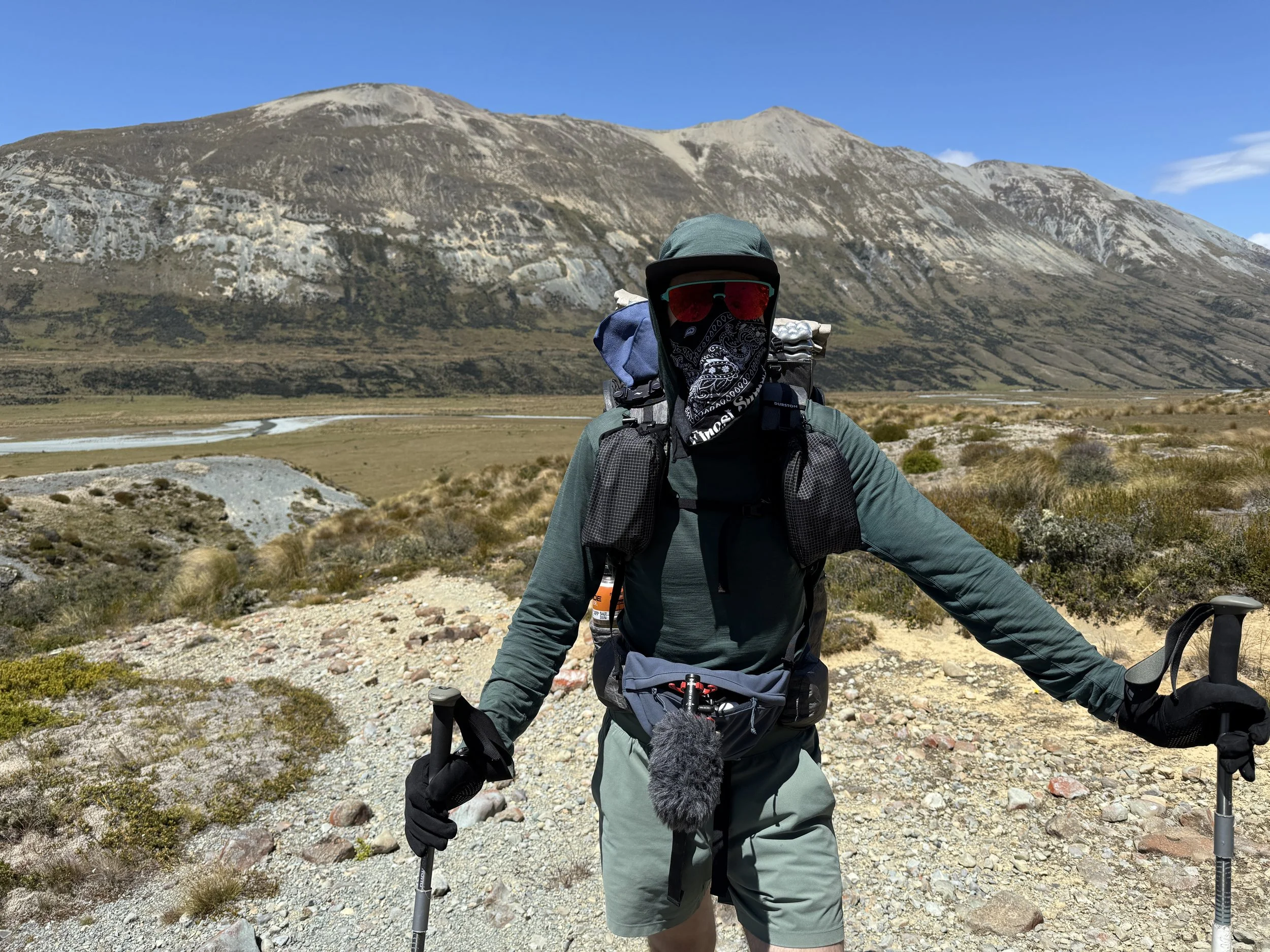
We finally mustered up the strength to pack up and get hiking around 9 am. The first 6 km were on 4x4 track and they were easy. Then we reached Boundary Hut. Here we crossed a suspension bridge (they are a bit unsettling) and stopped for an early lunch. I flew the drone because I just HAD to capture the landscape to share in my video from this stretch. MC Camel, a SOBO, stopped to eat with us and told us some tales of the trail. We aligned in our love of the alpine and a deserve to hike high routes.


The next 12 km to Taipo Hut were beautiful hiking. The trail was easy to follow, undulating, and passing through a large river valley. The sun was shining and our spirits rose with each step. The views were spectacular and it felt like the work we had done to get here was all worth it!
A bonus is, I seem less allergic to the Tussac than the grass! Yay!
We had a little snack break at the beautiful Taipo hut, where we met a solo SOBO. We have been enjoying our cold soaked noodles. Interestingly, the wind was strong and it was causing a hum on the roof of the hut.
We had 10 km to go to our final designation. We left Taipo at 4:30 pm and decided we should set down a good pace. It was great to hike quickly and efficiently.
Everything was going great and then, while I was leading, I lost the markers for a few hundred metres. I made the rash and uncharacteristic decision to try to cut back to the trail across the saddle. We couldn’t see it. Normally I would retrace my steps until the last marker I saw and then re-find the trail. I didn’t, and that caused a lot more effort, stress, and time wasted. Eventually we regained the trail and I didn’t feel great about the whole thing. Brian and I had a good discussion. I apologized for my response.

The trail was really easy to follow at this point and we cruised the final 5 km through the forest to Greenstone hut. We had a camp spot booking and we found the sites behind the hut. Set up on the flattest looking one, we are settled in for the night.
Today was exactly the day I needed to remind me why I’m out here. Of course thru hiking is always hard, but when the views pay off like they did today, it makes it all worth it!
Day 16: Greenstone Hut to Kinloch Campsite
A glorious sleep last night! I think I’m starting to turn a corner with my health and I am so extremely grateful for that!


We left the hut around 9 am and the trail down to the car park was about 11 km and beautifully cruisey!! We got into such a nice rhythm and kept looking around at the river and dramatic peaks. The trail was well maintained and I was able to walk in my shorts because the grass wasn’t brushing my legs. Wonderful!! We saw many day hikers headed up the path. We learned there is a popular multi day hiking loop in this area with well serviced huts along the way. I am always so happy to see so many people out enjoying the outdoors!


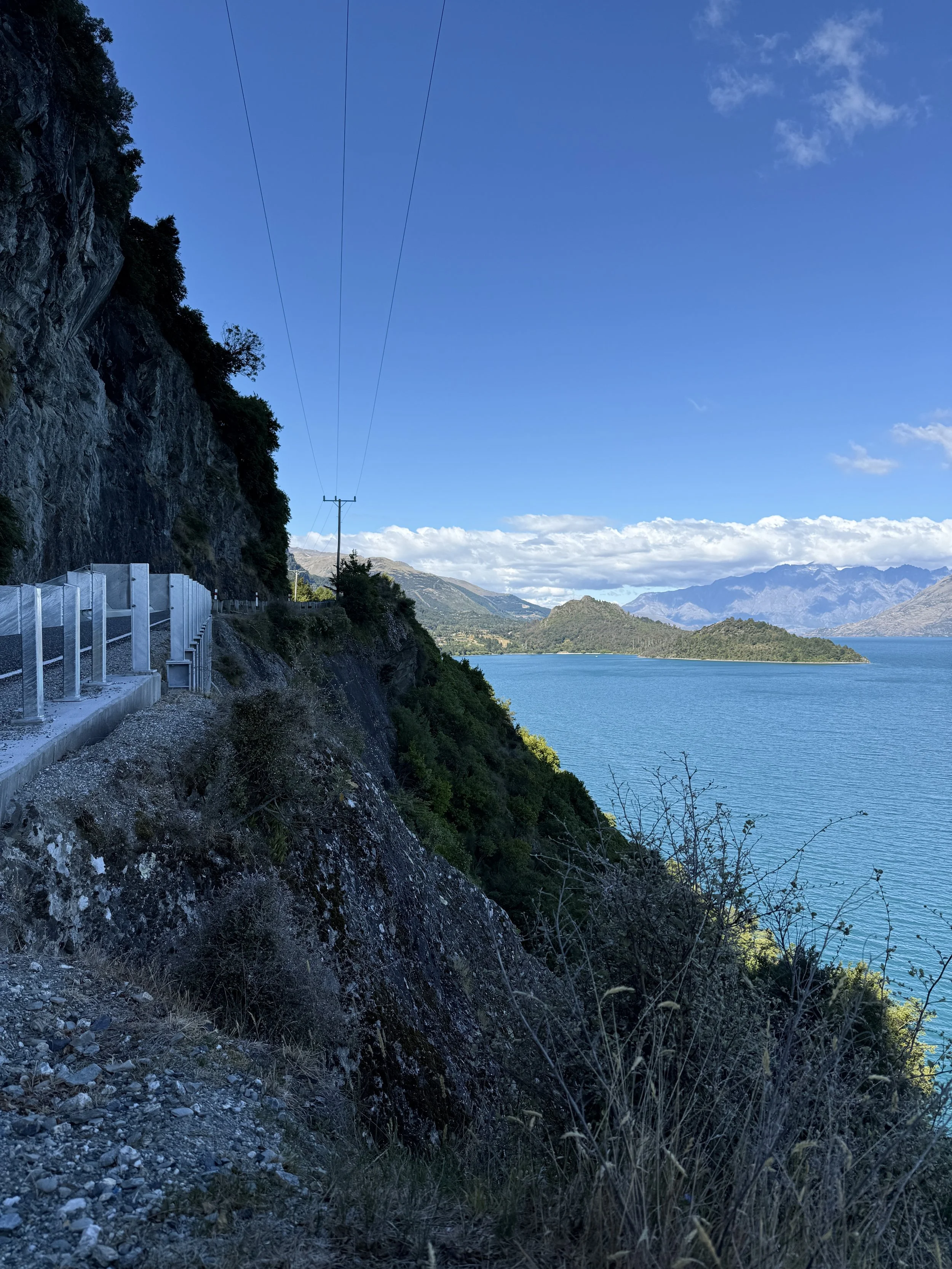
Once we reached the car park we had about 12 km to hike on the road to get to Kinloch Campsite. When I tell you this was the most beautiful road walk I’ve ever done, I am so serious. I would voluntarily walk this again for the views!
It was a gloriously sunny day and there were lots of little streams crossing the road for water. We arrived at the campsite at 5:15 pm and the restaurant across the street was still open!


We were able to order beers and bar snacks. It was incredible!!! The place is called Kinloch Wilderness retreat (https://kinlochlodge.co.nz/kinloch-dining/). We had looked into booking dinner, but it was pretty expensive. The bar snacks were filling and a more affordable option.
Our neighbours at the next table were locals who live just north on the trail. They were so generous in offering a ride once we were in the area and helping us with anything we needed!! We can’t get over the friendliness and generosity of the locals here.
This campsite has a gorgeous view! It’s a car camp site, but the road was quiet at night and the neighbours were so friendly! There was a group that was a little bit rowdy, but they shut things down by 10 pm. We set up the tent and went to bed after doing some video editing.
Day 17: Kinloch Campsite to Mrs Wolly’s Campsite (Glenorchy): 25 km
Today was technically optional. The TA Association states that if thru walkers choose to get a ride or shuttle around Lake Wakatipu that they should still consider their TA journey a thru walk. I think this is because of the absence of a good hiking route to get around the lake. Brian and I both really want this hike to be a continuous foot path. We love the poetic simplicity of walking an entire country from end to end. So that’s what we will try to do.


Today ended up being so fun!! We had breakfast across the street from our campsite and then headed out at 10 am. We were able to make really great time on the road and it wasn’t too busy. The mountain views were incredibly stunning. Another beautiful road walking day!
We stopped at the river to have lunch and fly the drone. I’ve been really loving getting to do some drone flights on this trail. It is so cool to see the landscape from above! I can’t wait to add these shots into my YouTube videos!
Another 10 km on the road. Brian and I both listened to something in our headphones and tried to keep up a good pace so that we would make it to Mrs Wooly’s before it closes.
We did it!! And I was loving this store! There were sheep themed items everywhere! Sheep soap, sheep stickers, sheep wool sweaters, sheep throw pillows, sheep candles, sheep greeting cards, etc. I was in heaven.


After browsing around for a while we bought 1.5 days worth of food (our main reason for being there). It was $100 for 1.5 days worth of food, which is much more expensive than the grocery store. It’s more of a souvenir shop than a grocery store.
We set up at our camp site next door at Mrs Wooly’s campground. It was a cute and cozy campground with great amenities. 10/10 would recommend. We lucked out and were here for taco truck night. It was a vibrant event with many locals, delicious tacos, and drinks. We had a great dinner, then headed back to our campground to shower and head to bed. Another day of road walking tomorrow!
Day 18: Mrs Wolly’s Campsite (Glenorchy) to Mount Creighton (an Airbnb): 33 km
We had a glorious sleep last night and were ready to crush out some road kilometres around Lake Wakatipu. The road walking was gorgeous, but a bit busier than yesterday. Overall the drivers were really great and we never had any close calls. We switched sides of the road depending on the width of the shoulder at times. We had a glorious lunch stop at the lake. It was a great day!
We are both starting to feel like we are hitting our groove on the trail now and it feels so so good! Checking into an Airbnb was a luxury I think we were both craving. Hot shower and a comfy bed?? Sign us up!!


Day 19: Mount Creighton to Queenstown: 18 km
We had a relaxing coffee gazing out at the lake from our Airbnb porch. We were both very content. We hit the trail at 10 and headed along the road to queenstown. The first 10 km were challenging, with narrow shoulders and lots of traffic. But once we reached the outskirts of town we had a nice path to walk on!

We were completely out of food, so I realized I was hangry when I was getting annoyed with everything. As soon as we got into town we grabbed lunch and that was absolutely glorious!
Queenstown is a picturesque town in an absolutely stunning location. I can only imagine how epic the skiing is in the winter with tall peaks all around. It’s a popular and busy tourist spot, which means lots of food options for us!!
We continued another 3 km along the lakeshore to our hotel on the outskirts of town. This meant it was a bit cheaper to stay at!
We headed back into town after a nap to shop for hiking pants for me and go out for dinner. We had a delicious Mexican meal and Margo’s and then saw some live music. We stayed up late in thru hikers terms!
It was easy to get an Uber back to our hotel. We fell asleep attempting to watch Lord of the Rings.


Day 20: Queenstown to Arrowtown: 25 km
We had a lovely breakfast and the vibe was so nice we ended up hanging out until 1 pm. We both realized with a start that we still had 25 km to hike to get to Arrowtown, so we packed up and hit the trail in the heat of the day.
The TA follows a beautiful lakeside trail, which was thankfully shaded a bunch of the time. The first town we reached was Frankton, where we needed to resupply. We went to the Woolworths and bought our food for the next 4 days. We also bought a nice spread for lunch and sat on a bench in the parking lot to eat it.
The next stretch was a combination of road walking, trail walking, and lakeshore paths. Walking from 6-9 pm as we reached Arrowtown was actually so lovely. It's a cooler part of the day and the days here are still so long (it's January).
We were able to do a late check-in at the campground. We ran into a few other TA hikers and then got set up.
Day 21: False start from Arrowtown: 0 km (+3 -3
We were up at 6 am to have an early-ish start. We got ready and hit the trail by 8 am. The route follows some local trails up into the mountains at first.
The climb was tough. I was moving slowly with my heavy pack filled with 4 days of food and in the heat. After about 3 km, we reached a part of the route that hugged contour line along the side of a ridge. As I took a step, the trail broke away under my right foot and I fell head-first down the steep slope. The fall all happened so fast, but I think I tucked and rolled because I remember falling onto my backpack against the ground before stopping in a thick clump of tall grass. My whole body was covered in pollen and superficial scrapes from the grass dragging across my skin. I was scared and winded.
The slope was so steep that Brian couldn't even get down to me. While lying on my face I had to unclip my backpack, put away my sunglasses and airpod, and brush myself off. I was able to pass my pack up to Sam, a fellow TA hiker that happened upon us right after my fall. Brian got one step down from the trail to help pull me up the steep slope. Sam checked my pack to ensure I wasn't missing any items of my gear (Stella and Bella my sheepsies, camera lens cap, DJI Osmo camera, water bottles, etc.) and everything seemed to be intact. I did a quick scan of my limbs to ensure nothing was broken and then climped up to the trail. I then did a more thorough body scan where a felt every inch of my body for any injuries. Everything felt good. We thanked Sam and he continued hiking. Then I sat down to catch my breath and let the adrenaline lower. I felt most worried about my neck, because I felt convinced I must have landed on my head.
After about 15 minutes, I taught Brian how to the do the neurological tests I know as a physiotherapist. We tested my sensation, strength, and reflexes. I assessed my neck movements and none felt painful. I palpated (touched) my neck vertebrae (bones) to check for any tenderness. All was within normal limits. We then started to discuss what we should do. I was rattled. I had fallen approximately 20 feet down a very steep slope. I could have easily kept falling. I got lucky. I didn't feel confident that continuing into the backcountry was the right call. So, we turned around.
It took us about 1.5 hours to drop back down into Arrowtown. We went for food and coffee and I relaxed for the rest of the day.


In next week’s blog I will tell you how I felt waking up the next morning and what we decided to do.
See you then!
-Story